Tuesday, November 28, 2006
Monday, October 16, 2006
Four Friends, Three Pads, Two Six-Packs Of Beer And One Uncharted Bouldering Area.
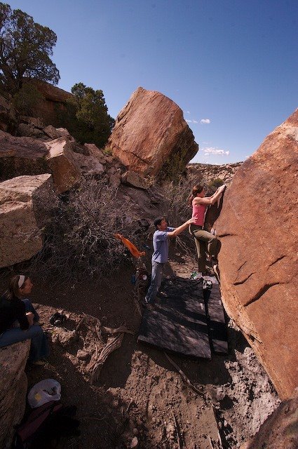
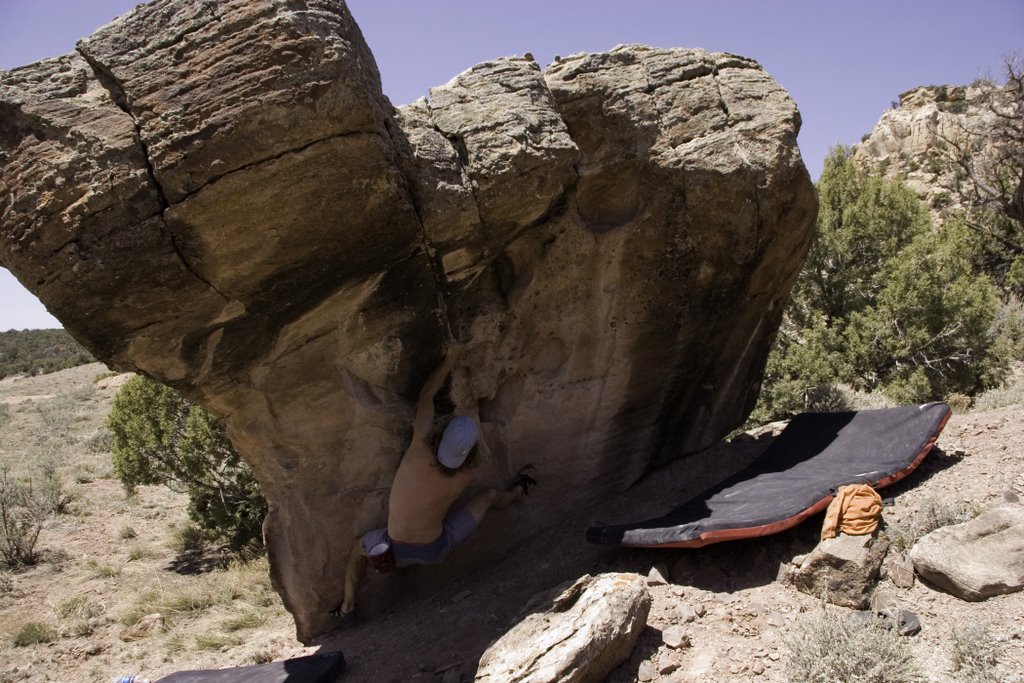
 In an attempt to find some form of climbing that is not far from the paved road—as the weather was taking a turn for the worst and there is nothing more exciting than driving the “clay-dirt” roads just outside of Disappointment Valley—Jim, Karen, Daiva and I went looking for boulders. Out of the vehicles for the first time in hours, Jim and I went for a bit of a jaunt. At first, the quality of what we were finding was not impressive. Later, back at the car, Jim said he had found a few boulders over a ridge that where worth a better look. So, what do we all do, we gear up and head-out. With clouds looming over head and rain eminent, we cached out pads and packs under an overhang at the first boulder we encountered and took off again in search of “it”—convinced it would rain before we would get a chance to climb. Boulder after boulder, we became convinced that the area had potential—OK it’s not the “mother-load” we were all hoping for, but it’ll do. Then we turned an observational corner and there “it” was (see photo ).
After an extensive examination of the boulders and convinced we would come back in the morning, we were “charged”—our motivation was very high. Back at our cache—it was not yet raining—we broke out the pads and got to work clearing landings, cleaning holds and working problems. Four hours, three boulders, two beers and a fist full of problems climbed, the sound of thunder and a wall of rain heading our way, we charged back to the car. Just in time.

 Normally, soft rock such as this cannot be climbed on after a serious soaking. Bummer for us! What to do? Head
 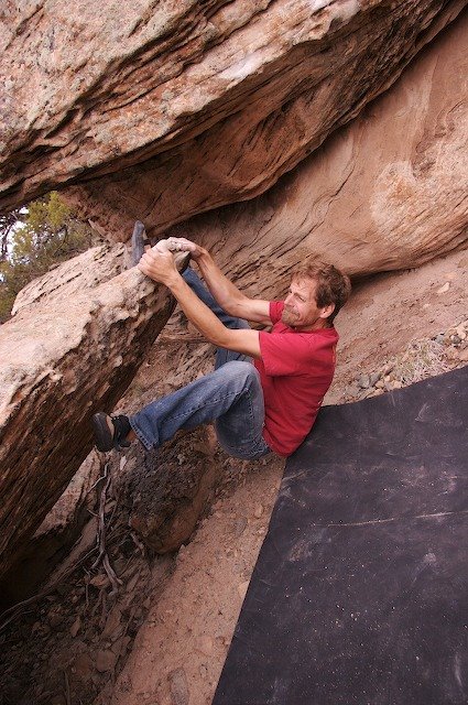 home, camp…. But the
  bouldering looked so damn good. The idea of setting up the tents in a down poor was not worth entertaining. We pulled our cars closer. After a minute of talking out loud, we decided to stick it out—in a cheep (very cheep) motel.
We would be back in the morning! And what a day we had. We wasted ourselves…by 5:00 pm we could climb no more. Here is some of what we found (photos).
And there is more! More what? More ridges, more boulders, more climbing—lots more!
Tuesday, October 10, 2006
Telluride Area Ice Conditions 2006/2007

Ice is here to stay. Winter is early. Here is a photo of BV Falls take 12-10-06.
Bear Creek ice is in good condition. Ames Falls is in also—slabs on the left and the main falls are climbable. Silver Pick Falls is in but thin (I have not been to the base yet this year, I have seen it from the road). It is snowing hard right now (8:00am 12-11-06). The Telluride Ski Area has accumulated well over 12 inches thus far (last 24 hrs) and there is no sign of it letting up. Climb safe!
Sunday, October 08, 2006
Tabeguache Climbing Area

Tabeguache climbing area is a hidden treasure sporting just over 14 bolted sport routes; albeit not easy to find, located well off the beaten path and easier to show on a map than to attempt to describe in words. But here goes; From Naturita, make a right on 97 (this will take you right to Nucla). Once in Nucla continue north to the end of town—continue straight along this road (97/Main St), it will begin heading west/left. Right on 27 Rd., stay left (27 Rd. will head off to the right)…you will now be on AA Rd (heading west). Right at Z26 Rd (north), and make a left at the “T” (staying on Z26 Rd.). This road will descend into a canyon and back up to a mesa. Once on the mesa heading north about a mile or so, look for a two-track road on the right (take this right). In a little ways you should pass an old crane (from the 50’s), then a fence (leave it how you found it). Then you come to a 4-way intersection (of the two-track dirt road type)—continue straight (same direction you are heading). From this intersection drive about 1/4 mile…look for an even less distinguishable road on your left—take it. This road will continue for some time and eventually begin to head left/west—this is the roughest part of the drive…look for a big, flat and seemingly open area to park. Look for a trail that heads to the top of the cliff—head left along the cliff. You will see anchors along the top of the cliff. Rap in or look for the weakness in the cliff (about 10 minutes hike). Also see The Wild Wild West climbing guide for a map (p. 172). I will create topo’s for this area in the future (as soon as I can use Illustrator on my MacBook Pro). Photo: Charlie Fowler on The Clean Air Standard, 5.11-. Other *** (three star) routes include Lichen It Alot, 5.10-, Tumbling Tumbleweeds, 5.11-, and Fair And Balanced, 5.11.
Wednesday, September 13, 2006
Back In Business

Just a warning for anyone attempting to run (CS2) Photoshop, InDesign and/or Illustrator on the new MacBook Pro—Do not load VQ or InDesign. Photoshop and Illustrator seem to run, albeit slowly for some people. Rosetta-the interface program designed interpret non-Universal programs on the new Intel System-is not designed to run CS2. Also, both Apple and Adobe say that CS2 is not compatable with the new MacBook Pro system. For more info from Apple. CS3 is on the way and is expected to be out in the next 6 to 12 months. Needles to say, I learned all this the hard way—several system crashes and many total reloads of my entire system (pain in the axx). So you have not seen may posts from me—sorry. I am back in business.
Also, just in case you are interested, I am now using Aperture to manage and edit photos for my blogs; I love it. This program rules for managing most aspects of your digital photos. It can not replace Photoshop for detailed photo manipulations, but it does the basics for dealing with Raw format photos.
Look forward to posting more…here is a photo from climbing up at the Falls Walls near Telluride this summer. No new routes up at this area, just beautiful views and fun climbs. This area has seen a lot of traffic this summer.
Wednesday, July 19, 2006
The Michelin Wall


For the past several weeks, I along with other good friends (Mark Dean, Charlie Fowler, Daiva Chesonis, Chris Boskoff) have been exploring more of the Telluride Conglomerate rock just west of the Pipeline Wall. So far we have been finding many high-quality routes. This topo includes some of our new routes established thus far. Access to these routes is not yet secured, in the legal sense that is. The Idarado Mining Company currently maintains some 361 mining claims, representing an estimated 7,435 acres of land holdings in the San Juan region. Much of this land will revert back to public lands in the near future. Until the land transfer is complete, however, it is best to approach this area via the standard Pipeline Wall access—though this will be a bit of an approach/bush-whack, the quality of the routes will make it worth the trouble. The upper right photo is DJ on the FA of Zen Lemonade.
The Routes (including those not on this topo)—from West to East/Left to Right:
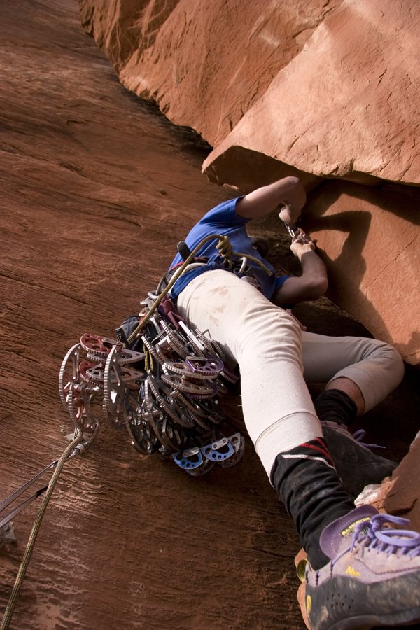
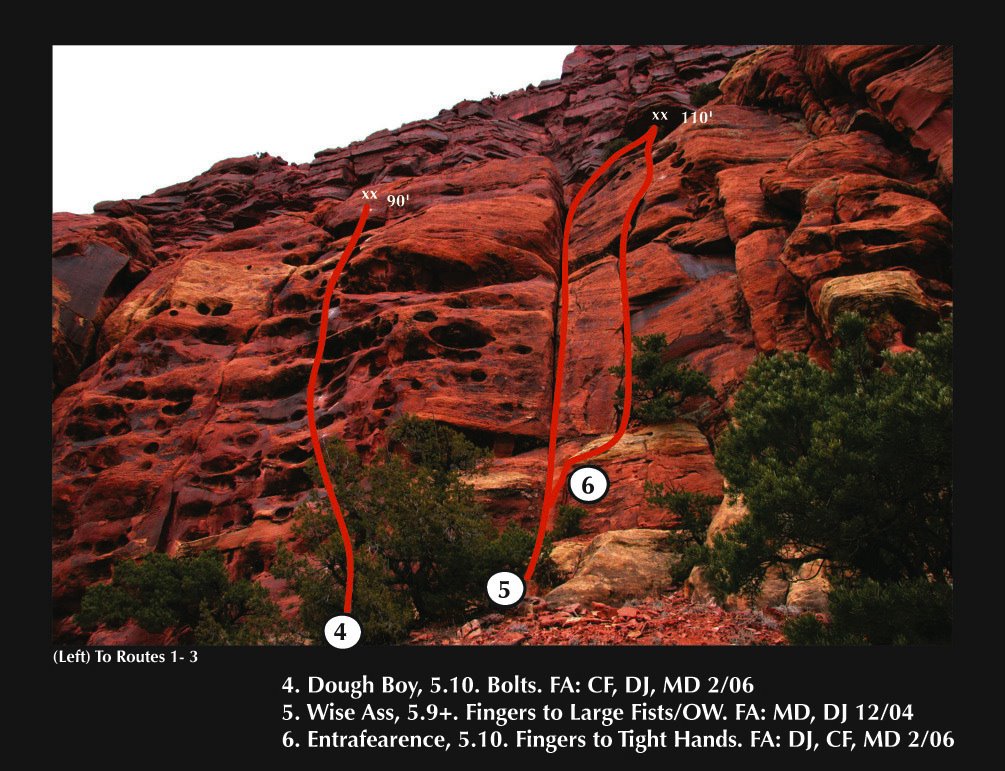
1) Trans Lunar Injection Burn, 5.11-, 3 Pitches. FA: DJ, MD, (DJ, CF, MD on Pitch 1; DJ & MD on Pitches 2 & 3). Pitch 1, 5.10-, (full 60m pitch) heads up a face to the right of the large broken-up (chossy) corner. Once you hit the steep head wall (just over 1/2 way up), head left into the crack for a few moves (you will use the crack for protection from here up. Traverse right across the ledge (second from the highest ledge) to the anchor. Gear 12 QD’s and two anchor rigs. Protection: .5 to #4 Camalots. Pitch 2, 5.11-,heads up the buttress 105’ to the next anchor (crux pitch). You can leave you natural gear from here on out and retrieve it on the way down—just draws and anchors. Pitch 3, 5.9+, 100’. Continue up the steep headwall for a few moves to the slab above. The grade backs off and the bolts are further part (PG 13, say). There is a small 4th pitch that leads to the large ledge above (I am recommending that climbers rap rather than walk off this route—mostly to avoid dropping rocks below-low 5th class down climbing/4th class should be expected). Rap.
2) Thunder Road, 5.9+, 1 Pitch (for now). This is a fun warm-up. You need 13 draws and something for the anchor. Fun route! Rap. FA: DJ, MD, CF, DC 6-06.
3) Zen Lemonade, 5.11-, 3 Pitches. Pitch 1, begin by climbing a roof to a steep face—100’. Pitch 2, head up and slightly left into the base of the large corner (the crux is climbing into the corner from below) 100’. Pitch 3, continues up the corner for a few body lengths then heads out and right onto the face (bolts) 100’. Gear: thin to wide hands, 12 draws, and two anchor rigs. Rap. FA: DJ, MD, CF 6-06.
4) Hokey Pokey, 5.9+ R, 1 Pitch (for now). Climb the left facing corner for 100’. Gear: lots of hands to OW (bring the big stuff). There are no bolts on this route but there may end up being a few in the near future as the OW is almost chimney like in a few places.
Routes 5—8 are east (up hill…not in photo). Charlie and Chris established a 4 pitch arête route that goes at 5.11…and they did a few single pitches to the right (east) of that. More on these routes soon.
There are several more routes to do in this area. At the moment I am waiting for more bolts from Petzl. There is also a lot of info to report from a “top-secret” area south of Rico (here is a photo Julie Hodson on a “fresh” route). More on this area later, but many, many new routes at the Carly Crag.

Tuesday, May 02, 2006
The Mine Fields

 After another visit to the surrounding boulder fields that are passed on the way to the 16Z climbing area expectations changed. But not for the worse, on Saturday (4/29/06) a rather large posy of climbers met in the epicenter of what we have come to realize is not a scattering of a few good boulders amongst a mass rubble heap, but a “mother-load” of superb, very high quality, boulders.
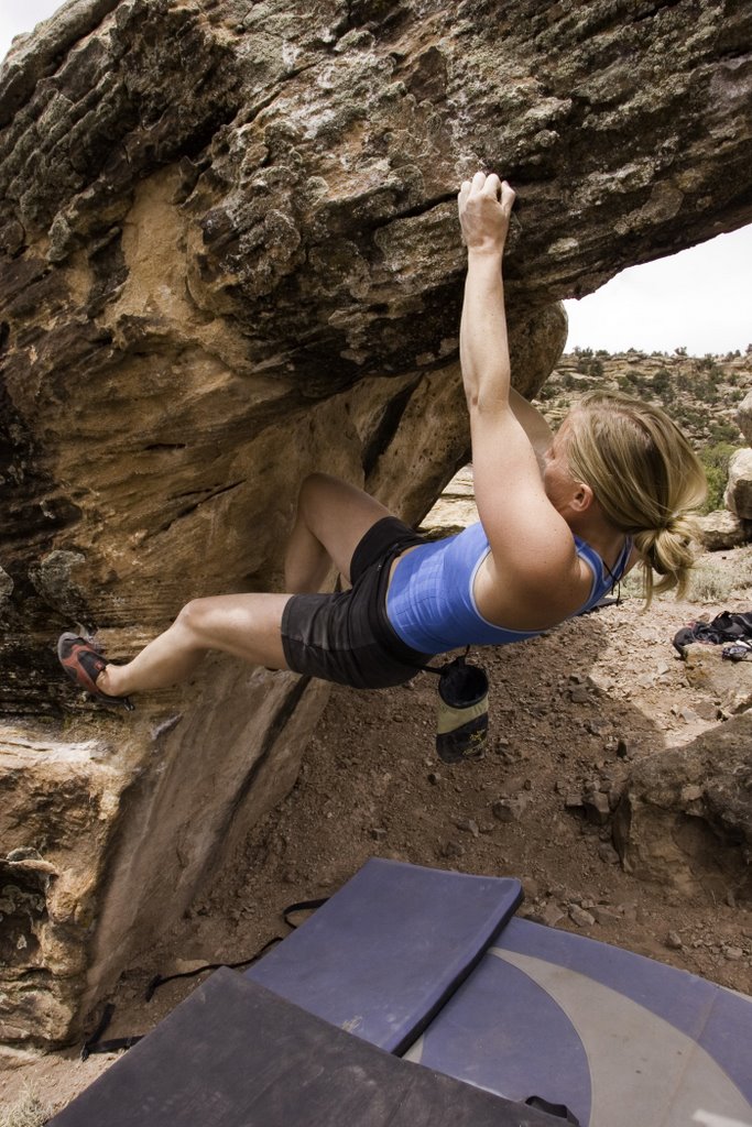
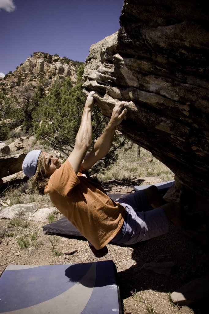
In the first four hours of cleaning off holds, buffing out landings and jumping on problems I realized that this place has some of the best bouldering I have ever done. Over two days I climbed on five boulders with problems ranging into V4 to V7. With the number of boulders out there we are expecting to find some seriously difficult problems. Here are a few photos of what we climbed and worked on.
Location: .5 miles west of the junction of 16Z rd & U29 rd (right and left sides of the valley).
Recommendations: Bring a lot of pads as many of the boulders are high and the landings are in the process of being modified. A nylon brush (in a few sizes) seems to work well on this sandstone. Bring lots of water!
Restrictions: The boulders are on BLM. There is established camping at the main parking are for 16Z (a few miles down the road to the west). Please do not create new camping in or near the boulders—we want to stay on the good side of the land managers.
Friday, April 28, 2006
16Z to Clay Creek

Over the past few weeks I have enjoyed the desert with good friends. 16Z has many amazing routes, few people and next to magical camping. On my last trip out there we “discovered” several high quality boulders (in quotations because many people have talked about having walked through them before). Since that time a few friends have gone back to clear landings and work various problems on many boulders. This area is accessed from the 16Z road and is encountered about half way to the main climbing area.
(Photos of this area and bouldering are forthcoming). See photo of Charlie Fowler on one of 16Z’s classic crack routes!
Another area visited recently is Clay Creek, location just outside of Norwood CO. This area has about 50 routes ranging from 40 to 50+ feet high—short but fun climbing. The short approach and sunny weather has made this area popular with the Ridgeway, Ouray, Telluride climbing contingent. It is possible to leave the mountains in Jan/Feb/Mar, where temperatures are near freezing, and encounter favorable temps and sunny conditions. See photo of Charlie on the first route established in this area, Dr. Evil, 5.11-.

Saturday, April 08, 2006
A Few Routes More

4-8-206: Up on the Sunshine Slabs (Y11/River Rd, 5.5 Miles north of Paradox Valley) Charlie and I established three new routes. The first route we did was just to the left of Dog-Collared-Women (see Blog below) that ascends a thin corner/seam through an overhang and finished up a thin face. We called this route Maybe Maybe Not, 5.11-, thin gear in the beginning then past three bolts (this route uses D-C-W’s anchor). Then to the climber’s left of this (and two the right of Manic Monday) we did two new crack lines: Donkey Kong Jr., 5.8, 70’ (a hand to thin hand crack in a corner that traverses left using a flake to the top—it was possible to place a 3.5 Camalot) and Donkey Kong, 5.9, 90’ (wide hands to OW—lots of big gear—Camalots #6 x 2, #5 x 1, #4.5 x 1, #4 x 2, #3.5 x 2, #3 x 4, #2 x 3). The beginning of this route takes some figuring-out. My only hint: Look for face holds.
Saturday, April 01, 2006
Another Killer Day In Southeast Utah
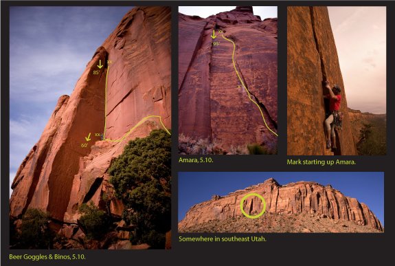
Comb Ridge, UT: Mark and I were able to slip in two new routes while clouds were rolling in from the west yesterday (3.31.2006). The first route we did we called Beer Goggles & Binos, 5.10. Mark began the first pitch to the right of the main corner which involves a fifty-foot traverse. I headed up the corner about 85 feet to a ledge inside a chimney. The gear (in order, Camalots): #2, #3, #4, #1, #2, #1, #1, .75 X many, .5 and a #1 and/or a 4.5 for the top is helpful.
Next, Mark ascended a fun crack/seam/face/flake up 95 feet and established an anchor. The route requires some tricky gear placements, ranging from a #4 Camalot and thin wires down low, to hands and .3 Camalots in the flake up high. Reaching the anchor, from exiting the flake, is the most committing move on the route. Mark named the route Amara, 5.10 (PG 13).
At the end of the day, just before the rain began, Mark and I took a walk along the cliff base just to get an idea of future projects. There were several thin finger corners and a few hand and OW sized routes to be done.
photo: Mark starting up Amara, 5.10 (PG 13), placing a #4 Camalot.
Thursday, March 30, 2006
Temporary Closure Of Mary Jane Draw
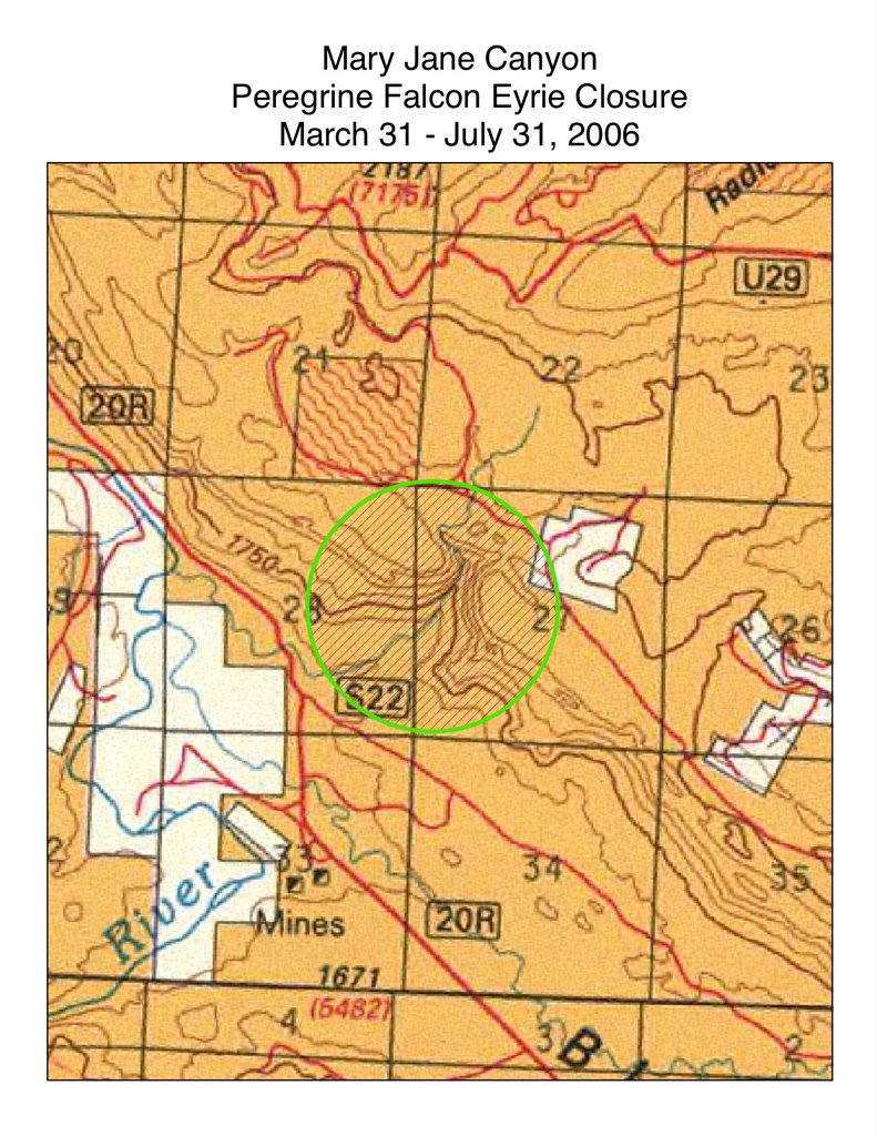
Paul Morey, Wildlife Biologist for the Dolores Public Lands Office Wrote:
“ …because the [peregrine's ] nest is likely somewhere within the Mary Jane Draw, we are going to have to put a closure into effect for the draw until the end of July. We will continue to monitor the canyon and if we decide the eyrie is either not in or near the draw, or we determine the eyrie has failed, the closure can be lifted before the end of July. Being a climber myself, it's always hard to put even temporary closures on climbing areas. But in this case, it's necessary for the peregrine's protection”.

I will update this blog if the closure is lifted before the end of July.
San Juan National Forest
San Juan BLM Resource Area
P.O. Box 210
Dolores, CO 81323
(970) 882-6853
(photo of Mark Dean on the Wonderer 5.10, Mary Jane Draw)
Tuesday, March 28, 2006
COMB RIDGE, UT

Sunday, March 19, 2006
Destroyed Simplicity
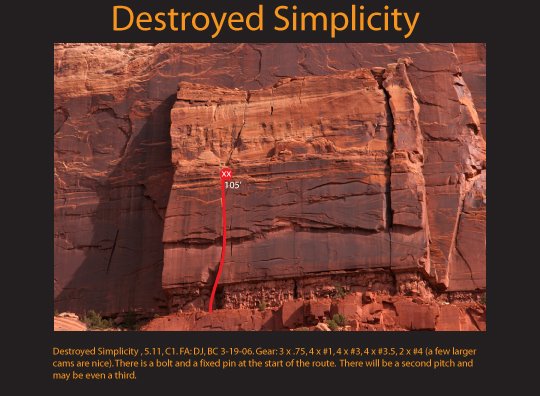
Up on Carpenter Ridge, new route activity is ongoing. Ben Clark and I established a new route to the east of the Paradise Wall-on the Bonanza Wall. We called it Destroyed Simplicity, 5.11, C1. The C1 will go free once the route sees a bit more cleaning. There is at least one additional pitch to add to this route, as well as a fun looking (but wide) two pitch route to the east of our route. At the moment, all roads to this area are over private property. There where no "NO Truspassing" sings on the way Ben and I used to make the approach drive. To date there are only a few routes in this area (as of March 18, 2006).
Also, Charlie Fowler and Chris Boskoff were busy putting the finishing touches on beautiful new route they called The Badger State, 5.11. To read more about their adventure Click-Here.
Sunday, March 05, 2006
The Sunshine Slabs Update
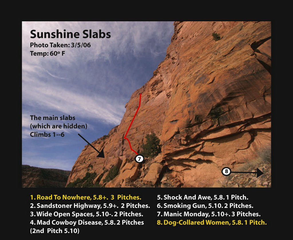
3-4-06: These incredibly fun slabs can be found just 5.5 north of Paradox Valley just off Y11 and/or River Road. This area has many moderate to easy climbs (5.8 to 5.10), most are two pitches and Manic Monday, the areas highest route, climbs three fun pitches up 300 feet. This week Charlie and I added two 70’ pitches to Road To Nowhere (5.8+). The first pitch is really an “approach pitch” to better climbing above. To the far right (past Manic Monday) we added a stellar 70’ arête/face climb we called Dog-Collared Women, 5.8. These south facing slabs provide the perfect location for winter rock climbing in the sun. Many of these routes require natural protection…for more info visit Wild Wild West Guide Book.
Wednesday, March 01, 2006
Telluride Ice Conditions Winter 2006
 3-2-06: Temps were in the upper 50's and it did not freez last night. This does not look good for ice conditions. NOAA's forcast for Friday
3-3-06: 20% of chance of snow, high is 39 degrees (F), cooling in the evening, only to heat up through the weekend. I will make an update to this next week.
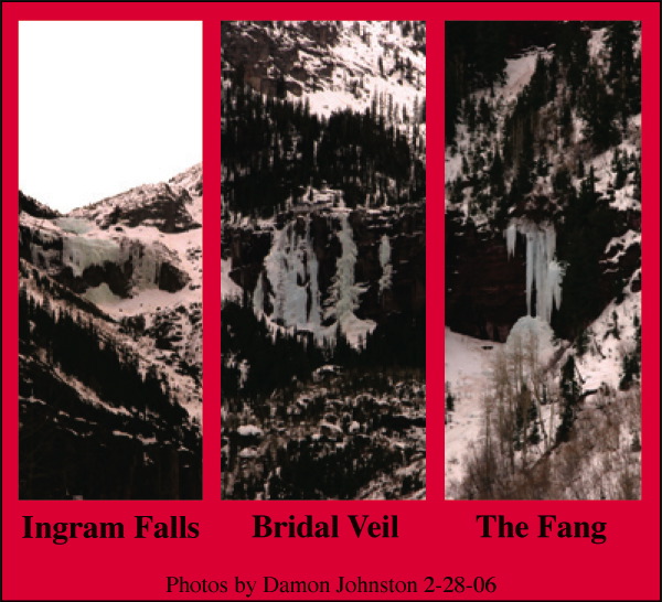
3-5-05: Well, the temps here were in the 50's (over that in the sun). A good friend of mine, Ben Clark, went out to climb at the Ames Falls and reported the climb was a dripping mess. Unless we get some cold temps several days in a row there may not be a recovery for the Ice in and around Telluride. Over all rating is poor-on the way to nonexistant.
3-8-06: Temps cooled off last night and as of 8:00am there was about 7 inches of new snow in the Telluride Area (and there is no sign of it slowing). Not sure if this will help the ice conditions, but the skiing conditions are improved (for a few days). Snow and cooler temps are in the forcast for rest of this week.
3-12-06: The Telluride area has had more than 30 inches of new snow (and it snowed last night for some time). The ice has improved some in that time. Cooler temps and no sun over the past several days has stopped rapped retreat of ice. In fact, new ice has accumulated on some routes. Overall conditions are still Poor, but are heading up the scale twards Moderate. The skiing in the Area is the best it has been all year!
3-15-06: Temps were warm on Tuesday the 14th, melting a lot of ice (anything in the sun). My good friend Charlie had this to say about the ice conditions "We went to Ames Falls yesterday morning [12th] and did a bunch of laps. The ice was cold but brittle and junky from too many warm days". Last night temps were warm (it did not freez at 9000'). Today will bring more warm temps. Ice conditions are still Poor in the Telluride area and are heading fast towards "hang up your ice tools, break out your cams".
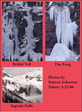
3-22-06: The Ice has grown a bit (see new photos). Over all conditions are still Poor. This week, temps have been cool and the area has seen some cloud cover. Heading out to the desert this weekend.
Monday, February 27, 2006
Fun In The Sun
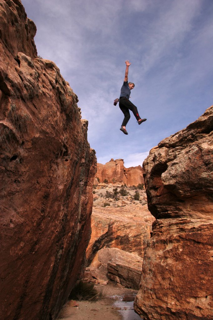
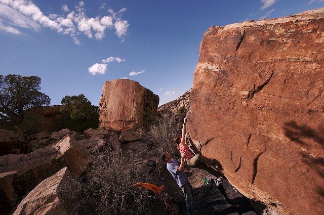
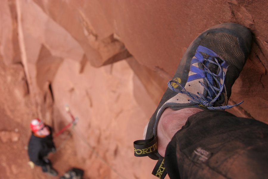
 You might think that you might need to hang up your climbing shoes as late October/ early November rolls around—not the case. Rock climbing in the San Juan’s is winding down about this time of year, but it is only just beginning in the desert to the west. The climbing is world class and has everything from four-pitch splitter Wingate climbs to single pitch sport routes, bouldering and everything in between. There are now something close to 600 routes west of Telluride. Red Rocks (not the one outside Las Vegas) is my favorite sport area (right now). Areas such as Carpenter Ridge are sporting 350+ foot crack routes—all trad (see photo of me on Cowboy Up—photo by Charlie Fowler). This was the first route to go up on this wall. The first pitch (the one in the photo) is 5.10+ and demands your attention for 140 feet. The second pitch (a mostly .5 Camalot-wide finger for me) is 5.12- (120 feet high) and the last pitch, a killer splitter that heads through a overhang (5.11+, 90 feet). This is truly an amazing climb. Also available in this region are many bouldering areas (see photo of Charlie Fowler making the jump between boulders). Late Oct, Nov., Dec, Jan, Feb, March through early April (and select days in the summer), these areas are prime for climbing on rock. Just make sure to bring lots of water and sunscreen. It is possible to find routes of all grades at most areas though some areas lend them selves to providing more of one general grade (easy, moderate and/or hard) than others.
Mild Peril

 A part of any good day in the desert are those moments just before sunset. It’s the end of the day, you have climbed hard and with any luck you will be back down at the car before dark. A beer from Mark Dean’s blue cooler awaits—nothing else could taste that good. Hanging out at the campfire in the evening, eating and talking about the details of the day’s efforts. If you were to attempt to explain your day to anyone else they would just look at you with a blank face—acknowledge what you said they might, but they can’t truly understand. But the people sitting with at the fire get it. They pick out every detail of what you are describing:
“From the belay at the top of the first pitch, head up twin cracks, the one on the left is protected with .2 and .1 Camalots (very thin), the right crack flairs but becomes better about 15 feet above and goes from .4 to 3 Camalots to the base of the overhang about 70 feet up. Cruiser. Climbing through the overhang is surly the crux, going from wide hands to OW (#3 to #4 Camalots), just as you pull the lip you are rewarded with a decent wide hand jam. Here is the where it becomes interesting. You can place a #6 Camalot in the pod above or skip it in favor of not having to climb by it on your way to the off-set crack at the top of the pod—it is an ok hand jam, but a fall would put you out in space (a solid ten feet away from the wall below), this is both good and bad, good because you know that the fall is safe, but bad because who wants to take a big fall only to have to collect yourself and head up for another stab. Not having the #6 would also get rid of some weight…to hell with it—you go for it. Once you are standing in the pod you have some time to relax. Another 20 feet and you are at the anchor (a tolerable location for a belay). There is a third pitch above that has a few large rocks to toss off…not enough large cams, it will have to wait until another day”.
The above is a description of the second pitch on a route done just the other day (Feb. 25, 2006) at Carpenter Ridge—lets hear it for Wingate—Mild Peril, 5.11+ (2 pitches at the moment with at least one more to go). Pitch 1; 5.11, 120’. Gear: .2, .3, .4 x 7, .5 x 2, 1, 4, 6-all Camalots (it is possible to get some other wide hands here and there if needed). This pitch climbs an OW for 20 feet or so, then opens into a pod, which offers some wide hands and stemming for about 10 feet and then enters a finger in a corner for 70 feet (.4 Camalots all the way to the anchor). A 70m rope is needed. FA: DJ, CF, BC 12/05. Pitch 2; 5.11+, 100’, (description above) FA: DJ, BC 2/06.
For more info on - Carpenter Ridge Climbs
Sunday, February 26, 2006
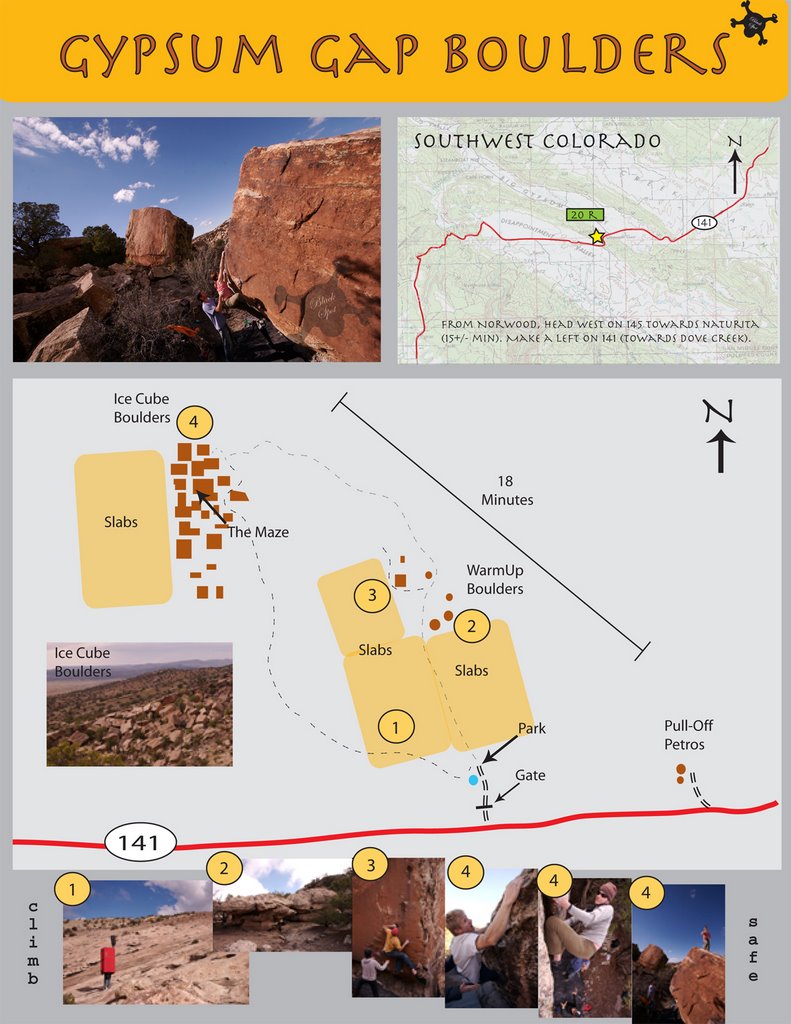
Big Gypsum Valley Up Date
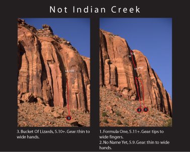
 Mary Jane Draw is located at the west end of Big Gypsum Valley in Southwest Colorado. Over the past few years this area has seen some climbing activity. The canyons walls are made up of four main layers of sandstone (Wingate forming the bottom layer, a shwag layer of Kayenta, Dakota forming next layer and Navajo forming the upper layer). In addition, the canyon can be broken up into east and west sides—each have their own approaches. All of the rock climbing to date has been on the top and bottom layers of rock. Climbing exploration began here many years ago. The lower band of Wingate (east side) has seen three new routes since the Wild Wild West Guidebook was published (see photo). This area has many new climbs to offer.
About Damon Johnston
 For many years now I have been exploring southwest Colorado with good friends (Charlie Fowler, Daiva Chesonis, Mark Dean, Joel Coniglio, Chris Boskoff, Rick Mendel and others). Together we have established hundreds of new rock climbs both in the mountains surrounding Telluride and in the desert areas around Paradox Valley and Big Gypsum Valley. Recently, my climbing and business partner Charlie Fowler and I started a media company (Mountain World Media LLC) through which we have published two guide books to rock climbing in the above areas. The Wild Wild West, published in late 2004, is a comprehensive guide book to over 500 desert rock climbs found in southwest Colorado (from Norwood west to the foot hills of the La Sal Mountains) . In late 2005, we published the third edition of Telluride Rocks—this expanded edition contains about 500 rock climbs, a brief coverage of bouldering areas and climbing information on 15 of Telluride’s most popular Mountains (Mt. Wilson, Wilson Peak, Lizard Head and many others). This blog is to be a dialog of adventures and exploration with friends. It is my intent to cover information on new climbing areas (the rock climbs therein), thoughts on issues ranging from photography to rock art and travels around the world.
Subscribe to:
Comments (Atom)